
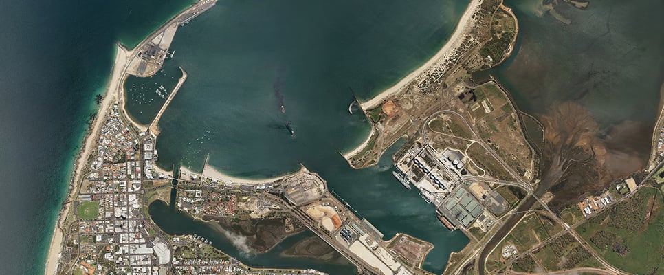
Capturing and sharing location data
Landgate manages the Capture WA Program, available for WA government agencies or local governments, giving them access to location data for their day-to-day business.
The program coordinates the capture and sharing of different types of location data from across WA.
The program continues to expand and evolve to balance the delivery of emerging technology with cost-effective solutions.
Any WA public sector agency or local government can participate in the program.
If you would like to explore the possibilities for your agency, please email Capture WA or visit Capture WA for more information.
Frequently asked questions
The program is open to any WA public sector agency or Local Government Authority that requires the capture of location information.
Any type of location data or data acquisition service can be requested though Capture WA. Although requests typically comprise of aerial imagery, the program accommodates geodetic surveying, vector (topographic and cadastral), LiDAR and bathymetry, DEMs and satellite imagery.
We understand that there are certain cases where capture outside of the program is warranted and appropriate.
If this does occur, please notify WALIS Council as your capture may be of benefit to other organisations and may avoid duplication across the sector.
Agencies can submit their requests at any time during the year, ideally with 3 months’ notice.
The program remains open year-round, so submissions can be made at any time.
- Submissions received before 30 April each year are prioritised and submitted to WALIS Council in late July for endorsement and scheduling in the following financial year’s program.
- Requests made after 30 April will be prioritised against available remaining program funding or may be rolled into the subsequent year’s program.
Actual delivery timeframes can be dependent on the contractor’s schedule, weather conditions, and environmental factors e.g. prescribed burning.
Before making a submission, clarify the type of capture (aerial, satellite, LiDAR) that will deliver the outputs your agency requires. A Landgate Landgate Customer Experience Consultant can assist with this advice.
Before making a submission, clarify the type of capture (aerial, satellite, LiDAR) that will deliver the outputs your agency requires. A Landgate Customer Experience Consultant can assist with this advice.
You will need to provide a data specification appropriate to your needs. If you are unsure, that advice can be provided by Landgate.
Once you are ready to submit your capture request, please visit the Capture WA Register. This is an online portal that tracks submissions and monitors requests.
To get started accessing the register, please email CaptureWA or talk to a Landgate Customer Experience Consultant.
The Landgate team will review the submissions and liaise internally with relevant Subject Matter Experts (SMEs), then provide the agency with an estimate of the cost and type of data.
Submissions are considered against broader government priorities and the value that can be achieved for multiple agencies through consolidating multiple requests.
Typically, Landgate’s Contract Manager will objectively review the submissions and provide a recommendation to the requesting agency based on value for money, IP Rights, fitness for purpose etc.
Landgate may consult with your agency SME to assess submissions for complex projects, or where your agency has contributed funding.
Generally, Landgate will recommend a technical specification that will deliver the outcomes your agency wants to achieve.
Scheduling will sometimes be dictated by supplier availability, spatial adjacency to other projects, prevailing weather conditions or a suitable time of the year, etc. Specific requests are accommodated whenever possible
Yes. Landgate Procurement operates within current State Government procurement policy, practice, legislation and regulations.
All costs are agreed before any contract is awarded and capture or supply activities occur. Landgate recommends you liaise with a Landgate Customer Experience Consultant as the initial point of contact. Costs are influenced by factors such as type of data requested, policies/procedures of the data custodian, and supplier mobilisation costs.
Costs for licensed data may vary between the various custodian agencies/types of data they supply. For charging purposes, Landgate classifies some information as Fundamental Land Information (FLI). This allows program-funded data to be supplied with a nominal cost of of extraction and provision. Non-FLI datasets may attract additional costs.
Landgate sets the program budget from within its existing expenditure limit, which typically varies between $1m and $2m per annum. To maximise the value from the program, agencies are encouraged to self-fund (agency covers all costs) or co-fund (program covers part costs) their requests to extend the available budget.
Co-funding / self-funding is beneficial to agencies as they enjoy the savings achieved through the competitive panel tender process.
This will also ensure the capture is delivered under standard terms and conditions with IP arrangements that allow the capture to be used for multiple purposes by multiple agencies. Landgate can also work with other agencies to contribute further funding for the capture to further reduce the costs for your agency.
Self-funded requests are assured of approval through the program, while co-funded requests are considered as part of the prioritisation process.
To expedite the process for co-funded/self-funded submission, please ensure agency funding is identified prior to making a request.
The program is funded from a discrete budget, and while every effort is made to accommodate as many requests as possible it is not always possible to fund or co-fund every submission.
Within budget limits and in certain circumstances, co-funding will be considered where the request demonstrates a broader, medium-term benefit to other agencies, improves the currency of data over a particular location, or can be accommodated alongside a complementary capture.
Payment for self, or co-funded captures are made on project completion. Landgate accepts payment prior to end of the financial year to assist with budgeting.
Yes. The core intent of the program is to deliver shared value across WA Government for the capture of location data. (i.e. capture once, use many times) Fees may apply for the handling and provision of the data and will be confirmed on a case by case basis.
The IP of any data captured (program, co-funded or self-funded) belongs to the State of Western Australia. Landgate manages this on behalf of the State. Licencing arrangements will determine the allowable use of the data.
Depending on the nature of the data and the location, sharing IP rights will often be used to significantly reduce the cost of acquisition, and consequently will make the capture budget go further. As a result, the supplier has the rights to commercialise the data for their own client base.
Yes. Whilst data acquisitions made through Capture WA usually have an alignment with an agency specific objective and used for internal or planning purposes, we recognise that data acquisitions may need to be shared with collaborating Government agencies and/or contractors/consultants (under licence) in the delivery of a defined output. However, the data must be deleted by the contractor/consultant at the project’s conclusion.
Landgate recognises that sometimes it is more convenient to have data stored locally, therefore data can be made available on an agency-supplied hard disk drive for the cost of extraction and provision.
| Task | Responsibility | Comment |
| Performance monitoring of the contractor | Landgate | Landgate |
| Minor dispute resolution | Landgate | Ensuring expectations, specifications, and timeframes form part of the RFT/RFQ assists in avoiding this issue |
| Major dispute resolution | Landgate/agency | Dispute and escalation procedures are addressed as part of the contract award |
| Dispute and escalation procedures are addressed as part of the contract award | Contractors/suppliers | |
| Insurance compliance | Contractors/suppliers | |
| Payments and remuneration arrangements including invoice processing | Landgate | |
| Extensions, variations, termination | Landgate |